Point Cloud Capture in Phoenix

    Dense 3D measurement data for BIM and CAD workflows

    Point cloud capture creates millions of precise 3D coordinates representing your physical space, ready for integration with BIM software, CAD applications, and visualization tools.

    Computer monitor displaying colorful 3D point cloud visualization of a building interior scan with millions of measurement points

    What is Point Cloud Capture?

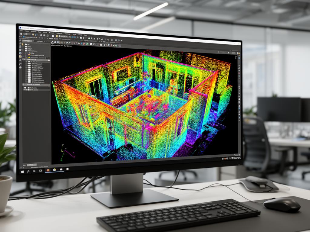
    A point cloud is a collection of millions of individual data points, each representing a specific location in three-dimensional space. Point cloud capture uses laser scanning or LiDAR technology to measure these points, creating a comprehensive digital representation of physical environments.

    Each point in the cloud has X, Y, and Z coordinates, and typically includes additional data such as color information and laser intensity. When viewed together, these millions of points create a visually recognizable 3D model of the scanned space that can be measured, analyzed, and used for design work.

    Point cloud data is the foundation for many downstream applications including 2D CAD drawings, 3D BIM models, clash detection, and virtual documentation. The data can be delivered in multiple file formats compatible with industry-standard software.

    Common Applications

    • BIM model creation and scan-to-BIM workflows
    • Existing conditions documentation
    • Design verification and clash detection
    • Virtual site documentation
    • Measurement and analysis
    • Integration with CAD and design software

    We deliver point cloud data in industry-standard formats compatible with Autodesk, Bentley, Trimble, and other major software platforms.

    Benefits of Point Cloud Capture

    Millions of Data Points

    Capture millions of precise measurements in a single scan. More data means more accurate representations of your space.

    BIM-Ready Deliverables

    Point cloud data integrates directly with BIM software for scan-to-BIM workflows, model verification, and clash detection.

    Multiple Format Options

    Receive data in formats compatible with your software: E57, RCP, RCS, LAS, XYZ, and more.

    Color & Intensity Data

    Point clouds include color photography and laser intensity data, making it easier to identify materials and features.

    Measure Anywhere, Anytime

    Once captured, point cloud data can be measured and analyzed remotely without returning to the site.

    Archive Quality Documentation

    Point cloud data serves as a permanent, measurable record of existing conditions at the time of capture.

    Our Point Cloud Capture Process

    1

    Requirements Discussion

    We discuss your intended use for the point cloud data, software compatibility needs, and required level of detail.

    2

    Scanning Strategy

    We plan scan positions to ensure complete coverage at the density level required for your application.

    3

    Data Capture

    Our team captures overlapping scans from multiple positions. Each scan takes 2-10 minutes depending on resolution settings.

    4

    Registration & Cleanup

    We align all scans into a unified point cloud, remove noise and artifacts, and verify data quality.

    5

    Format Conversion & Delivery

    We convert point cloud data to your required formats and deliver via secure file transfer or physical media for large datasets.

    Point Cloud Capture Use Cases

    Scan-to-BIM Projects

    Provide point cloud data as the foundation for BIM model creation. Accurate existing conditions support renovation design and coordination.

    Design Verification

    Compare design models to actual as-built conditions. Identify discrepancies and verify construction accuracy.

    Clash Detection

    Overlay proposed designs on existing conditions point clouds to identify potential conflicts before construction.

    Remote Measurement

    Take measurements from point cloud data without returning to the site. Extract distances, areas, and volumes from your desk.

    Virtual Documentation

    Create immersive virtual walkthroughs and documentation of existing conditions for stakeholder review.

    Historic Preservation

    Document historic structures and details with high-density point cloud capture for preservation and restoration projects.

    Point Cloud Capture Pricing Factors

    Point cloud capture cost depends on project scope and data requirements:

    Coverage Area

    More area requires more scan positions and longer capture time. Complex spaces with many rooms require more positions than open areas.

    Point Density

    Higher density (more points per area) requires more scan positions and longer processing. Specify density based on your intended use.

    File Format Requirements

    Basic formats (E57, LAS) are standard. Specialized formats or multiple format deliveries may add processing time.

    Data Management

    Very large point clouds may require segmentation, coordinate system setup, or specialized delivery methods.

    Typical project investment: Point cloud capture projects in Phoenix typically range from $2,000-$10,000+ depending on scope and density requirements. Large or complex projects may exceed this range.

    Frequently Asked Questions

    Request a Point Cloud Capture Quote

    Get a detailed proposal for your Phoenix-area project. We typically respond within one business day.